
Wood County topographic map
Interactive map
Click on the map to display elevation.
About this map
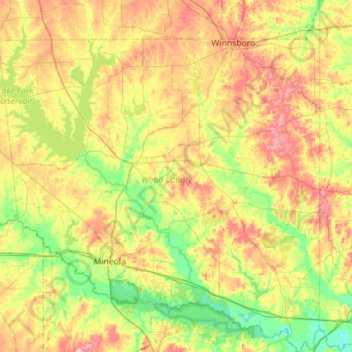
Name: Wood County topographic map, elevation, terrain.
Location: Wood County, Texas, United States (32.54066 -95.66531 33.01327 -95.15128)
Average elevation: 131 m
Minimum elevation: 80 m
Maximum elevation: 203 m
Other topographic maps
Click on a map to view its topography, its elevation and its terrain.
Holly Lake Ranch
United States > Texas > Wood County
Holly Lake Ranch, Wood County, Texas, 75765, United States
Average elevation: 122 m
Hawkins
United States > Texas > Wood County
Hawkins, Wood County, Texas, United States
Average elevation: 118 m
Quitman
United States > Texas > Wood County > Quitman
Quitman, Wood County, Texas, 75783, United States
Average elevation: 120 m