
Carbon County topographic map
Interactive map
Click on the map to display elevation.
About this map
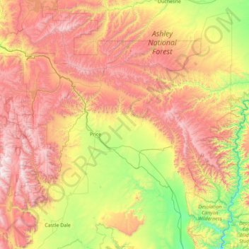
Name: Carbon County topographic map, elevation, terrain.
Location: Carbon County, Utah, United States (39.46733 -111.24751 39.81413 -109.87396)
Average elevation: 2,128 m
Minimum elevation: 1,260 m
Maximum elevation: 3,362 m
Other topographic maps
Click on a map to view its topography, its elevation and its terrain.
Price
United States > Utah > Carbon County
Price, Carbon County, Utah, 84591, United States
Average elevation: 1,711 m
Spring Glen
United States > Utah > Carbon County > Spring Glen
Spring Glen, Carbon County, Utah, 84526, United States
Average elevation: 1,800 m
Price
United States > Utah > Carbon County > Price
Price, Carbon County, Utah, United States
Average elevation: 1,711 m