
Berkhamsted topographic map
Interactive map
Click on the map to display elevation.
About this map
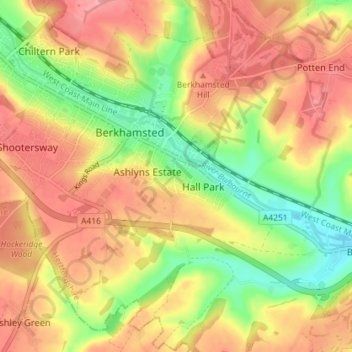
Name: Berkhamsted topographic map, elevation, terrain.
Location: Berkhamsted, Dacorum, Hertfordshire, England, United Kingdom (51.73573 -0.59360 51.77455 -0.52201)
Average elevation: 142 m
Minimum elevation: 90 m
Maximum elevation: 182 m
The layout of Berkhamsted's centre is typical of a medieval market settlement: the linear High Street (aligned on the Akeman Street) forms the spine of the town (roughly aligned east–west), from which extend medieval burgage plots (to the north and south). The surviving burgage plot layout is the result of a comprehensive plan carried out at the beginning of the 13th century, most probably instigated by Geoffrey fitz Peter. The town centre slowly developed over the years and contains a wide variety of properties that date from the 13th century onwards. The modern town began to develop after the construction of the Grand Junction Canal in 1798. The canal intersects the river at numerous points, taking most of its water supply and helping to drain the valley. The locality became further urbanised when the London to Birmingham railway was built in 1836–37. The townscape was shaped by the Bulbourne valley, which rises 300 feet (91 metres) on either side at its narrowest point; the residential area is elongated and follows the valley's topography. The southwest side of the valley is more developed, with side streets running up the steep hillside; on the northeast side, the ground gently slopes down to the castle, railway, canal and small river, was less available for development. Today, Berkhamsted is an affluent, "pleasant town tucked in a wooded fold in the Chiltern Hills"; with a large section of the settlement protected as a conservation area.
Other topographic maps
Click on a map to view its topography, its elevation and its terrain.
Hemel Hempstead
United Kingdom > England > Hertfordshire > Dacorum
Hemel Hempstead, Dacorum, Hertfordshire, England, HP1 1EW, United Kingdom
Average elevation: 130 m
Wigginton
United Kingdom > England > Hertfordshire > Dacorum > Wigginton
Wigginton, Dacorum, Hertfordshire, England, United Kingdom
Average elevation: 174 m
Old Dean
United Kingdom > England > Hertfordshire > Dacorum > Bovingdon
Old Dean, Bovingdon, Felden, Dacorum, Hertfordshire, England, United Kingdom
Average elevation: 144 m
Little Heath
United Kingdom > England > Hertfordshire > Dacorum > Potten End
Little Heath, Nettleden with Potten End, Potten End, Dacorum, Hertfordshire, England, HP4 2RX, United Kingdom
Average elevation: 138 m
Moorend
United Kingdom > England > Hertfordshire > Dacorum > Corner Hall
Moorend, Corner Hall, Dacorum, Hertfordshire, England, HP1 1JP, United Kingdom
Average elevation: 121 m
Northchurch
United Kingdom > England > Hertfordshire > Dacorum > Northchurch
Northchurch, Dacorum, Hertfordshire, England, United Kingdom
Average elevation: 162 m
Tringford Reservoir
United Kingdom > England > Hertfordshire > Dacorum > Tring > Wilstone
Tringford Reservoir, Tring, Wilstone, Dacorum, Hertfordshire, England, United Kingdom
Average elevation: 119 m
Hammerfield
United Kingdom > England > Hertfordshire > Dacorum > Hemel Hempstead
Hammerfield, Hemel Hempstead, Dacorum, Hertfordshire, England, HP1 1TA, United Kingdom
Average elevation: 122 m
Saint Margarets Copse
United Kingdom > England > Hertfordshire > Dacorum > Great Gaddesden
Saint Margarets Copse, St. Margarets Farm, Great Gaddesden, Dacorum, Hertfordshire, England, United Kingdom
Average elevation: 144 m
Hastoe
United Kingdom > England > Hertfordshire > Dacorum > Tring
Hastoe, Tring, Dacorum, Hertfordshire, England, HP23 6LX, United Kingdom
Average elevation: 197 m
Tring
United Kingdom > England > Hertfordshire > Dacorum
Tring, Dacorum, Hertfordshire, England, United Kingdom
Average elevation: 168 m
Markyate
United Kingdom > England > Hertfordshire > Dacorum
Markyate, Dacorum, Hertfordshire, England, United Kingdom
Average elevation: 154 m
Astrope
United Kingdom > England > Hertfordshire > Dacorum > Long Marston
Astrope, Tring Rural, Long Marston, Dacorum, Hertfordshire, England, HP23 4PJ, United Kingdom
Average elevation: 91 m
Piccotts End
United Kingdom > England > Hertfordshire > Dacorum
Piccotts End, Dacorum, Hertfordshire, England, HP1 3AU, United Kingdom
Average elevation: 132 m
Old Town
United Kingdom > England > Hertfordshire > Dacorum
Old Town, Dacorum, Hertfordshire, England, HP1 3AF, United Kingdom
Average elevation: 124 m
Little Gaddesden
United Kingdom > England > Hertfordshire > Dacorum > Little Gaddesden
Little Gaddesden, Dacorum, Hertfordshire, England, United Kingdom
Average elevation: 175 m
Bovingdon
United Kingdom > England > Hertfordshire > Dacorum
Bovingdon, Dacorum, Hertfordshire, England, United Kingdom
Average elevation: 147 m
Aldbury
United Kingdom > England > Hertfordshire > Dacorum
Aldbury, Dacorum, Hertfordshire, England, United Kingdom
Average elevation: 174 m
Frithsden Beeches
United Kingdom > England > Hertfordshire > Dacorum > Potten End
Frithsden Beeches, Northchurch, Potten End, Dacorum, Hertfordshire, East of England, England, HP4 1PU, United Kingdom
Average elevation: 160 m
Flamstead
United Kingdom > England > Hertfordshire > Dacorum > Flamstead
Flamstead, Dacorum, Hertfordshire, England, United Kingdom
Average elevation: 148 m
Kings Langley
United Kingdom > England > Hertfordshire > Dacorum
Kings Langley, Dacorum, Hertfordshire, England, United Kingdom
Average elevation: 111 m
Long Marston
United Kingdom > England > Hertfordshire > Dacorum > Long Marston
Long Marston, Dacorum, Hertfordshire, East of England, England, HP23 4RL, United Kingdom
Average elevation: 92 m
Corner Hall
United Kingdom > England > Hertfordshire > Dacorum
Corner Hall, Dacorum, Hertfordshire, England, HP3 9EE, United Kingdom
Average elevation: 120 m
Flaunden
United Kingdom > England > Hertfordshire > Dacorum
Flaunden, Dacorum, Hertfordshire, England, United Kingdom
Average elevation: 125 m
Potten End
United Kingdom > England > Hertfordshire > Dacorum
Potten End, Dacorum, Hertfordshire, England, HP4 2QH, United Kingdom
Average elevation: 141 m