
Mississauga topographic map
Interactive map
Click on the map to display elevation.
About this map
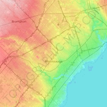
Name: Mississauga topographic map, elevation, terrain.
Location: Mississauga, Peel Region, Golden Horseshoe, Ontario, Canada (43.47899 -79.81032 43.73706 -79.53856)
Average elevation: 151 m
Minimum elevation: 70 m
Maximum elevation: 263 m
The shoreline of former Glacial Lake Iroquois roughly follows the Dundas Street alignment, although it is not noticeable in some places but is more prominent in others, such as the site of the former brickyard (Shoreline Dr. near Mavis Rd.), the ancient shoreline promenteau affords a clear view of downtown Toronto and Lake Ontario on clear days. The land in Mississauga in ranges from a maximum elevation of 214 m (699 ft) ASL in the far western corner, near the Hwy. 407/401 junction, to a minimum elevation at the Lake Ontario shore of 76 m (249 ft) above sea level.
Other topographic maps
Click on a map to view its topography, its elevation and its terrain.
Brampton
Canada > Ontario > Peel Region
Brampton, Peel Region, Golden Horseshoe, Ontario, Canada
Average elevation: 223 m
Caledon
Canada > Ontario > Peel Region
Caledon, Peel Region, Golden Horseshoe, Ontario, L7C 2Z2, Canada
Average elevation: 311 m
Old Malton
Canada > Ontario > Peel Region > Mississauga
Old Malton, Mississauga, Peel Region, Golden Horseshoe, Ontario, Canada, Cattrick Park
Average elevation: 172 m
Caledon East
Canada > Ontario > Peel Region > Caledon
Caledon East, Caledon, Peel Region, Golden Horseshoe, Ontario, L7C 1H9, Canada
Average elevation: 308 m
Caledon
Canada > Ontario > Peel Region > Caledon
Caledon, Peel Region, Golden Horseshoe, Ontario, Canada
Average elevation: 331 m