
Jaglot topographic map
Interactive map
Click on the map to display elevation.
About this map
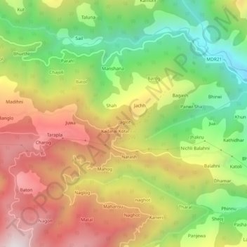
Name: Jaglot topographic map, elevation, terrain.
Location: Jaglot, Karsog, Mandi, Himachal Pradesh, 175011, India (31.34795 77.27665 31.38795 77.31665)
Average elevation: 1,659 m
Minimum elevation: 1,092 m
Maximum elevation: 2,261 m
Other topographic maps
Click on a map to view its topography, its elevation and its terrain.
Jaglot
India > Himachal Pradesh > Karsog
Jaglot, Karsog, Mandi District, Himachal Pradesh, 175011, India
Average elevation: 1,653 m
Rohai
India > Himachal Pradesh > Karsog > Pangna
Rohai, Pangna, Karsog, Mandi, Himachal Pradesh, 175046, India
Average elevation: 1,619 m
Sunni
India > Himachal Pradesh > Karsog > Sunni
Sunni, Karsog, Mandi, Himachal Pradesh, India
Average elevation: 768 m