
Keystone topographic map
Interactive map
Click on the map to display elevation.
About this map
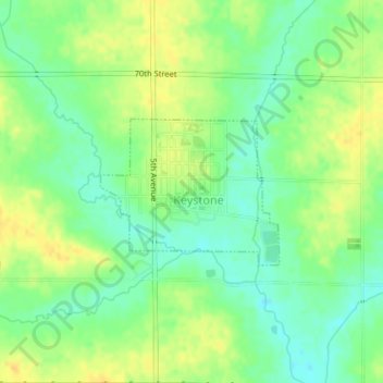
Name: Keystone topographic map, elevation, terrain.
Location: Keystone, Benton County, Iowa, 52249, United States (41.99427 -92.20724 42.00457 -92.19027)
Average elevation: 272 m
Minimum elevation: 259 m
Maximum elevation: 285 m
Other topographic maps
Click on a map to view its topography, its elevation and its terrain.
Blairstown
United States > Iowa > Benton County
Blairstown, Benton County, Iowa, United States
Average elevation: 261 m
Garrison
United States > Iowa > Benton County
Garrison, Benton County, Iowa, United States
Average elevation: 274 m
Walford
United States > Iowa > Benton County
Walford, Benton County, Iowa, 52351, United States
Average elevation: 251 m
Newhall
United States > Iowa > Benton County
Newhall, Benton County, Iowa, United States
Average elevation: 273 m