
La Chorrera topographic map
Interactive map
Click on the map to display elevation.
About this map
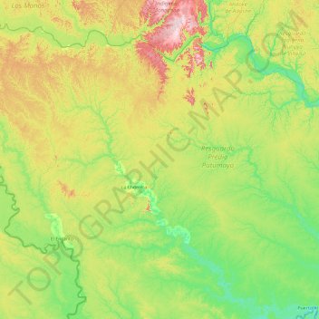
Name: La Chorrera topographic map, elevation, terrain.
Location: La Chorrera, Amazonas, Colombia (-2.18506 -73.84130 -0.38010 -71.97995)
Average elevation: 155 m
Minimum elevation: 83 m
Maximum elevation: 359 m
Other topographic maps
Click on a map to view its topography, its elevation and its terrain.
Vda. San Antonio
Colombia > Amazonas > Vda. San Antonio
Vda. San Antonio, La Chorrera, Amazonas, Colombia
Average elevation: 143 m