
Emerald Beach topographic map
Interactive map
Click on the map to display elevation.
About this map
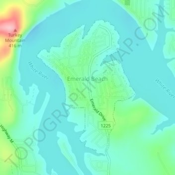
Name: Emerald Beach topographic map, elevation, terrain.
Location: Emerald Beach, Barry County, Missouri, 65658, United States (36.56380 -93.68159 36.58472 -93.66265)
Average elevation: 299 m
Minimum elevation: 267 m
Maximum elevation: 422 m
Other topographic maps
Click on a map to view its topography, its elevation and its terrain.
Chain-O-Lakes
United States > Missouri > Barry County > Chain-O-Lakes
Chain-O-Lakes, Barry County, Missouri, United States
Average elevation: 296 m