
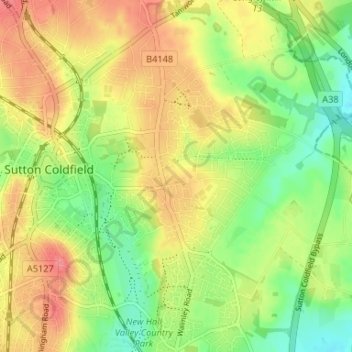
Reddicap Heath topographic map
Interactive map
Click on the map to display elevation.
About this map
Name: Reddicap Heath topographic map, elevation, terrain.
Average elevation: 121 m
Minimum elevation: 88 m
Maximum elevation: 154 m
Other topographic maps
Click on a map to view its topography, its elevation and its terrain.
Banners Gate
United Kingdom > England > Birmingham > Sutton Coldfield > New Oscott
Banners Gate, Sutton Coldfield, New Oscott, Birmingham, West Midlands Combined Authority, England, B73 6SH, United Kingdom
Average elevation: 144 m
Walmley Ash
United Kingdom > England > Birmingham > Sutton Coldfield > Walmley
Walmley Ash, Sutton Coldfield, Walmley, Birmingham, West Midlands Combined Authority, England, B76 1YH, United Kingdom
Average elevation: 99 m
Maney
United Kingdom > England > Birmingham > Sutton Coldfield > Boldmere
Maney, Sutton Coldfield, Boldmere, Birmingham, West Midlands Combined Authority, England, B72 1JH, United Kingdom
Average elevation: 128 m