
Elkins topographic map
Interactive map
Click on the map to display elevation.
About this map
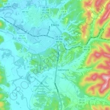
Name: Elkins topographic map, elevation, terrain.
Location: Elkins, Randolph County, West Virginia, 26241, United States (38.87325 -79.87408 38.94134 -79.83184)
Average elevation: 637 m
Minimum elevation: 576 m
Maximum elevation: 861 m
Elkins is located at the confluence of the Tygart Valley River and Leading Creek. The average elevation is 2,000 feet (610 m) above sea level. According to the United States Census Bureau, the city has a total area of 3.43 square miles (8.88 km2), all land. Elkins is headquarters for the Monongahela National Forest, a 910,155-acre (368,327 ha) federal reserve encompassing the "High Alleghenies" area to the east of the city.