
Navarro County topographic map
Interactive map
Click on the map to display elevation.
About this map
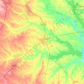
Name: Navarro County topographic map, elevation, terrain.
Location: Navarro County, Texas, United States (31.79629 -96.89618 32.32906 -96.05329)
Average elevation: 131 m
Minimum elevation: 73 m
Maximum elevation: 223 m
Other topographic maps
Click on a map to view its topography, its elevation and its terrain.
Corsicana
United States > Texas > Navarro County > Corsicana
Corsicana, Navarro County, Texas, United States
Average elevation: 128 m