
Sam Brown Creek topographic map
Interactive map
Click on the map to display elevation.
About this map
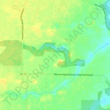
Name: Sam Brown Creek topographic map, elevation, terrain.
Average elevation: 49 m
Minimum elevation: 36 m
Maximum elevation: 59 m
Other topographic maps
Click on a map to view its topography, its elevation and its terrain.
Aurora
United States > Oregon > Marion County
Aurora, Marion County, Oregon, United States
Average elevation: 43 m
Silverton
United States > Oregon > Marion County
Silverton, Marion County, Oregon, 97381, United States
Average elevation: 103 m
Butteville
United States > Oregon > Marion County > Butteville
Butteville, Marion County, Oregon, United States
Average elevation: 53 m
Salem
United States > Oregon > Marion County
Salem, Marion County, Oregon, United States
Average elevation: 96 m