
Foster County topographic map
Interactive map
Click on the map to display elevation.
About this map
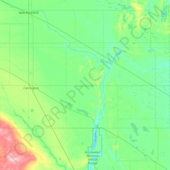
Name: Foster County topographic map, elevation, terrain.
Location: Foster County, North Dakota, United States (47.32684 -99.26805 47.58875 -98.49907)
Average elevation: 473 m
Minimum elevation: 435 m
Maximum elevation: 637 m
Other topographic maps
Click on a map to view its topography, its elevation and its terrain.
Glenfield
United States > North Dakota > Foster County
Glenfield, Foster County, North Dakota, United States
Average elevation: 457 m
Carrington
United States > North Dakota > Foster County
Carrington, Foster County, North Dakota, 58421, United States
Average elevation: 484 m