
Singur topographic map
Interactive map
Click on the map to display elevation.
About this map
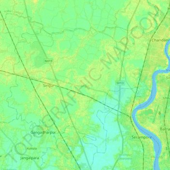
Name: Singur topographic map, elevation, terrain.
Location: Singur, Hugli, West Bengal, India (22.73704 88.17683 22.88923 88.38373)
Average elevation: 8 m
Minimum elevation: -3 m
Maximum elevation: 17 m
Other topographic maps
Click on a map to view its topography, its elevation and its terrain.
Chandannagar
India > West Bengal > Singur
Chandannagar, Singur, Hugli, West Bengal, 712136, India
Average elevation: 8 m