
Osage County topographic map
Interactive map
Click on the map to display elevation.
About this map
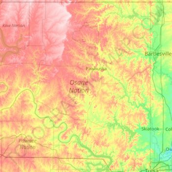
Name: Osage County topographic map, elevation, terrain.
Location: Osage County, Oklahoma, United States (36.16079 -97.06701 36.99929 -96.00046)
Average elevation: 277 m
Minimum elevation: 175 m
Maximum elevation: 413 m
Holmes Peak is a mountain northwest of Tulsa in Osage County. It was named by the United States Board on Geographic Names on October 5, 1983 for the fictional detective, Sherlock Holmes. The name was proposed by Richard S. Warner. Holmes Peak is the highest point in the Tulsa Metropolitan area, with an elevation of 1,030 feet (310 m), though it ranks only as the 379th highest point in the state.
Other topographic maps
Click on a map to view its topography, its elevation and its terrain.
Skiatook
United States > Oklahoma > Osage County
Skiatook, Osage County, Oklahoma, 74070, United States
Average elevation: 222 m
Foraker
United States > Oklahoma > Osage County
Foraker, Osage County, Oklahoma, United States
Average elevation: 385 m
Fairfax
United States > Oklahoma > Osage County
Fairfax, Osage County, Oklahoma, United States
Average elevation: 259 m
Herd
United States > Oklahoma > Osage County
Herd, Osage County, Oklahoma, United States
Average elevation: 287 m