
Sugar City topographic map
Interactive map
Click on the map to display elevation.
About this map
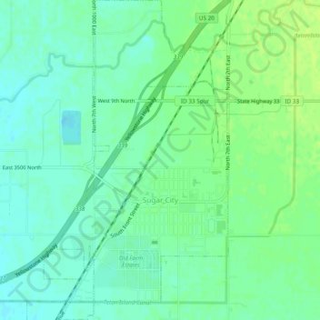
Name: Sugar City topographic map, elevation, terrain.
Location: Sugar City, Madison County, Idaho, United States (43.86013 -111.77751 43.89447 -111.73789)
Average elevation: 1,494 m
Minimum elevation: 1,487 m
Maximum elevation: 1,500 m
Sugar City is located at 43°52′20″N 111°44′50″W / 43.87222°N 111.74722°W / 43.87222; -111.74722 (43.872317, -111.747331), at an elevation of 4,895 feet (1,492 m) above sea level.