
Lawrence Township topographic map
Interactive map
Click on the map to display elevation.
About this map
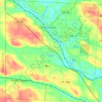
Name: Lawrence Township topographic map, elevation, terrain.
Location: Lawrence Township, Stark County, Ohio, 44666, United States (40.82229 -81.64802 40.91430 -81.53644)
Average elevation: 318 m
Minimum elevation: 281 m
Maximum elevation: 376 m
Other topographic maps
Click on a map to view its topography, its elevation and its terrain.
Massillon
United States > Ohio > Stark County
Massillon, Stark County, Ohio, 44647, United States
Average elevation: 321 m
North Canton
United States > Ohio > Stark County
North Canton, Stark County, Ohio, United States
Average elevation: 341 m
Louisville
United States > Ohio > Stark County
Louisville, Stark County, Ohio, 44641, United States
Average elevation: 350 m
North Industry
United States > Ohio > Stark County
North Industry, Stark County, Ohio, 44707, United States
Average elevation: 333 m
East Sparta
United States > Ohio > Stark County
East Sparta, Stark County, Ohio, United States
Average elevation: 310 m
New Franklin
United States > Ohio > Stark County
New Franklin, Paris Township, Stark County, Ohio, United States
Average elevation: 365 m
Canton
United States > Ohio > Stark County
Canton, Stark County, Ohio, United States
Average elevation: 335 m
Canal Fulton
United States > Ohio > Stark County > Canal Fulton
Canal Fulton, Stark County, Ohio, 44614, United States
Average elevation: 308 m