
Perry County topographic map
Interactive map
Click on the map to display elevation.
About this map
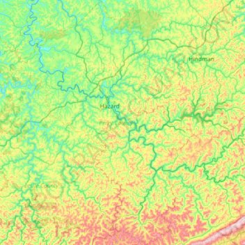
Name: Perry County topographic map, elevation, terrain.
Location: Perry County, Kentucky, United States (36.99185 -83.55394 37.44354 -83.00014)
Average elevation: 425 m
Minimum elevation: 232 m
Maximum elevation: 864 m
Other topographic maps
Click on a map to view its topography, its elevation and its terrain.
Combs
United States > Kentucky > Perry County
Combs, Perry County, Kentucky, 41729, United States
Average elevation: 338 m
Buckhorn
United States > Kentucky > Perry County
Buckhorn, Perry County, Kentucky, United States
Average elevation: 307 m
Hazard
United States > Kentucky > Perry County > Hazard > Hazard
Hazard, Perry County, Kentucky, 41729, United States
Average elevation: 369 m