
Nakuru topographic map
Interactive map
Click on the map to display elevation.
About this map
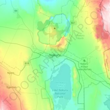
Name: Nakuru topographic map, elevation, terrain.
Location: Nakuru, Kenya (-0.44027 35.91120 -0.12027 36.23120)
Average elevation: 1,993 m
Minimum elevation: 1,717 m
Maximum elevation: 2,703 m
On 3 June 2021, Nakuru was officially endorsed for city status after the Kenyan Senate voted for its elevation from a Municipality. The President of the Republic of Kenya will need to give a city charter for official transformation to city status. If and once given the charter, Nakuru will be the fourth city of Kenya after Nairobi city, Mombasa city and Kisumu city.