
Manchester topographic map
Interactive map
Click on the map to display elevation.
About this map
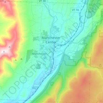
Name: Manchester topographic map, elevation, terrain.
Location: Manchester, Bennington County, Vermont, United States (43.11664 -73.13504 43.21472 -73.00170)
Average elevation: 453 m
Minimum elevation: 189 m
Maximum elevation: 1,163 m
Manchester is located in north-central Bennington County, lying between the Green Mountains to the east and the Taconic Range to the west. Equinox Mountain, the highest summit in the Taconics, with an elevation of 3,850 feet (1,170 m), is in the western part of the town. Manchester is drained by the Batten Kill, Lye Brook, Munson Brook, Bromley Brook, and Bourn Brook. The Lye Brook Falls Hiking Trail which leads to one of the highest waterfalls in Vermont is a popular local attraction.
Other topographic maps
Click on a map to view its topography, its elevation and its terrain.
Searsburg
United States > Vermont > Bennington County
Searsburg, Bennington County, Vermont, United States
Average elevation: 675 m
North Bennington
United States > Vermont > Bennington County > Bennington
North Bennington, Bennington, Bennington County, Vermont, 05257, United States
Average elevation: 196 m
Bennington
United States > Vermont > Bennington County
Bennington, Bennington County, Vermont, United States
Average elevation: 352 m
Pownal
United States > Vermont > Bennington County
Pownal, Bennington County, Vermont, United States
Average elevation: 369 m
Readsboro Falls
United States > Vermont > Bennington County > Readsboro
Readsboro Falls, Readsboro, Bennington County, Vermont, 05350, United States
Average elevation: 637 m
Landgrove
United States > Vermont > Bennington County
Landgrove, Bennington County, Vermont, United States
Average elevation: 479 m
Woodford
United States > Vermont > Bennington County > Woodford
Woodford, Bennington County, Vermont, 05201, United States
Average elevation: 670 m
Sandgate
United States > Vermont > Bennington County
Sandgate, Bennington County, Vermont, United States
Average elevation: 480 m
Rupert
United States > Vermont > Bennington County
Rupert, Bennington County, Vermont, United States
Average elevation: 360 m
Shaftsbury
United States > Vermont > Bennington County
Shaftsbury, Bennington County, Vermont, 05262, United States
Average elevation: 395 m
Stamford
United States > Vermont > Bennington County
Stamford, Bennington County, Vermont, 05352, United States
Average elevation: 646 m