
Neyshabur City topographic map
Interactive map
Click on the map to display elevation.
About this map
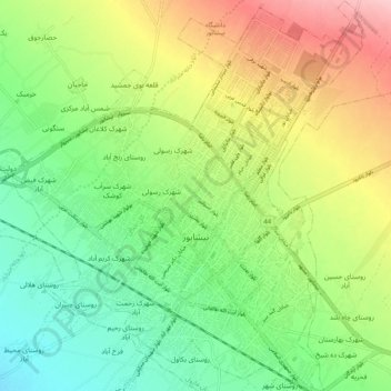
Name: Neyshabur City topographic map, elevation, terrain.
Average elevation: 1,208 m
Minimum elevation: 1,147 m
Maximum elevation: 1,302 m
Nishapur is located at an elevation of 1213 meters on a wide fertile plain at the southwestern foot of the Binalud Mountain range in northcentral Razavi Khorasan Province. The city is connected by both railways and highways to Mashhad, Tehran and the South Khorasan Province. Among its agricultural products are cereals and cotton. Pottery making and carpet weaving are among its important handicrafts.
Other topographic maps
Click on a map to view its topography, its elevation and its terrain.
شهرک رسولی
Iran > Razavi Khorasan > Neyshabur County > Neyshabur City
شهرک رسولی, Neyshabur City, بخش مرکزی شهرستان نیشابور, Neyshabur County, Razavi Khorasan, 93138-33138, Iran
Average elevation: 1,201 m