
Lahijan topographic map
Interactive map
Click on the map to display elevation.
About this map
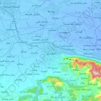
Name: Lahijan topographic map, elevation, terrain.
Average elevation: 23 m
Minimum elevation: -19 m
Maximum elevation: 464 m
The topographic position of the Caspian lowlands results in a very characteristic Hyrcanian climate, and the whole province of Gilan belongs to this humid and green area. Prevailing north-south atmospheric currents, humidified over the Caspian, are forced to a vigorous ascendancy by the mighty barrier of Alborz and thus pour abundant rainfall all year long on both the plain and the north-western slope of the mountains. The precipitation regime shows a sharp maximum in autumn (September to December), when atmospheric instability is at its highest point, medium values in winter and early spring, and lowest values from May to August.