
Make a donation
Gear up for your next adventure:
As an Amazon Associate, this site earns from qualifying purchases at no extra cost to you.
New Haven topographic map
Click on the map to display elevation.
Make a donation
Gear up for your next adventure:
As an Amazon Associate, this site earns from qualifying purchases at no extra cost to you.
About this map
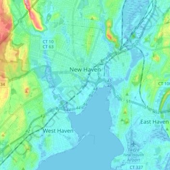
Name: New Haven topographic map, elevation, terrain.
Average elevation: 20 m
Minimum elevation: -3 m
Maximum elevation: 138 m
Make a donation
Gear up for your next adventure:
As an Amazon Associate, this site earns from qualifying purchases at no extra cost to you.
Other topographic maps
Click on a map to view its topography, its elevation and its terrain.
Sea Bluff
United States > Connecticut > South Central Connecticut Planning Region > West Haven > West Shore
Average elevation: 14 m
Killingworth Court
United States > Connecticut > South Central Connecticut Planning Region > New Haven
Average elevation: 13 m
Hein Trails
United States > Connecticut > South Central Connecticut Planning Region > Bethany > Davidsons Corner
Average elevation: 175 m
Indian Neck
United States > Connecticut > South Central Connecticut Planning Region > Branford
Average elevation: 4 m
Make a donation
Gear up for your next adventure:
As an Amazon Associate, this site earns from qualifying purchases at no extra cost to you.
Northford
United States > Connecticut > South Central Connecticut Planning Region > North Branford
Average elevation: 71 m
Ansonia
United States > Connecticut > South Central Connecticut Planning Region
Average elevation: 111 m
Derby
United States > Connecticut > South Central Connecticut Planning Region
According to the United States Census Bureau, the town has a total area of 5.4 square miles (8.7 km2), of which, 5.0 square miles (13 km2) is land and 0.4 square miles (1.0 km2) (7.41%) is water. The city is home to the 417 acres (0.652 sq mi) Osbornedale State Park. Derby is divided into two main sections by…
Average elevation: 79 m
Momauguin
United States > Connecticut > South Central Connecticut Planning Region > East Haven
Average elevation: 3 m
Make a donation
Gear up for your next adventure:
As an Amazon Associate, this site earns from qualifying purchases at no extra cost to you.
Indian Cave
United States > Connecticut > South Central Connecticut Planning Region > Guilford
Average elevation: 25 m
North Madison
United States > Connecticut > South Central Connecticut Planning Region > Madison
Average elevation: 91 m
Nut Plains
United States > Connecticut > South Central Connecticut Planning Region > Guilford
Average elevation: 35 m
Fort Trumbull
United States > Connecticut > South Central Connecticut Planning Region > Milford
Average elevation: 7 m
Make a donation
Gear up for your next adventure:
As an Amazon Associate, this site earns from qualifying purchases at no extra cost to you.
Branford Court
United States > Connecticut > South Central Connecticut Planning Region > New Haven
Average elevation: 13 m
West Shore
United States > Connecticut > South Central Connecticut Planning Region > West Haven
Average elevation: 9 m
North Haven Bridge
United States > Connecticut > South Central Connecticut Planning Region > North Haven
Average elevation: 22 m
Lake Whitney
United States > Connecticut > South Central Connecticut Planning Region > Hamden > Whitneyville
Average elevation: 25 m
Make a donation
Gear up for your next adventure:
As an Amazon Associate, this site earns from qualifying purchases at no extra cost to you.
West Shore
United States > Connecticut > South Central Connecticut Planning Region > West Haven
Average elevation: 9 m
South End Point
United States > Connecticut > South Central Connecticut Planning Region > East Haven > Momauguin
Average elevation: 2 m
Lake Whitney
United States > Connecticut > South Central Connecticut Planning Region > Hamden
Average elevation: 25 m
Forest Heights
United States > Connecticut > South Central Connecticut Planning Region > Milford
Average elevation: 19 m
Make a donation
Gear up for your next adventure:
As an Amazon Associate, this site earns from qualifying purchases at no extra cost to you.
Silver Beach
United States > Connecticut > South Central Connecticut Planning Region > Milford > Fort Trumbull
Average elevation: 5 m
Branford Hills
United States > Connecticut > South Central Connecticut Planning Region > Branford
Average elevation: 12 m
East Peak
United States > Connecticut > South Central Connecticut Planning Region > Meriden
Average elevation: 154 m
Momauguin
United States > Connecticut > South Central Connecticut Planning Region > East Haven
Average elevation: 3 m
Make a donation
Gear up for your next adventure:
As an Amazon Associate, this site earns from qualifying purchases at no extra cost to you.
Silver Beach
United States > Connecticut > South Central Connecticut Planning Region > Milford
Average elevation: 5 m
Nut Plains
United States > Connecticut > South Central Connecticut Planning Region > Guilford
Average elevation: 35 m
South Meriden
United States > Connecticut > South Central Connecticut Planning Region > Meriden
Average elevation: 55 m
Bayview
United States > Connecticut > South Central Connecticut Planning Region > Milford
Average elevation: 5 m
Make a donation
Gear up for your next adventure:
As an Amazon Associate, this site earns from qualifying purchases at no extra cost to you.
Brightview
United States > Connecticut > South Central Connecticut Planning Region > New Haven
Average elevation: 5 m
Fort Trumbull
United States > Connecticut > South Central Connecticut Planning Region > Milford
Average elevation: 7 m
Sea Bluff
United States > Connecticut > South Central Connecticut Planning Region > West Haven > West Shore
Average elevation: 14 m
Mount Carmel Center
United States > Connecticut > South Central Connecticut Planning Region > Hamden
Average elevation: 79 m
Make a donation
Gear up for your next adventure:
As an Amazon Associate, this site earns from qualifying purchases at no extra cost to you.
Morningside
United States > Connecticut > South Central Connecticut Planning Region > Milford
Average elevation: 5 m
East River
United States > Connecticut > South Central Connecticut Planning Region > Madison
Average elevation: 9 m
Big Indian
United States > Connecticut > South Central Connecticut Planning Region > Guilford
Average elevation: 41 m
Sunset Hill
United States > Connecticut > South Central Connecticut Planning Region > Branford
Average elevation: 12 m
Make a donation
Gear up for your next adventure:
As an Amazon Associate, this site earns from qualifying purchases at no extra cost to you.
Sea Bluff
United States > Connecticut > South Central Connecticut Planning Region > West Haven > West Shore
Average elevation: 14 m
Clark Hill
United States > Connecticut > South Central Connecticut Planning Region > Milford
Average elevation: 11 m
Peter's Rock
United States > Connecticut > South Central Connecticut Planning Region > North Haven
Average elevation: 38 m
Quinnipiac
United States > Connecticut > South Central Connecticut Planning Region > Wallingford
Average elevation: 31 m
Make a donation
Gear up for your next adventure:
As an Amazon Associate, this site earns from qualifying purchases at no extra cost to you.
North Branford Town Green
United States > Connecticut > South Central Connecticut Planning Region > North Branford
Average elevation: 44 m
Fair Haven East
United States > Connecticut > South Central Connecticut Planning Region > New Haven
Average elevation: 14 m
Allingtown
United States > Connecticut > South Central Connecticut Planning Region > West Haven
Average elevation: 26 m