
Nashville topographic map
Interactive map
Click on the map to display elevation.
About this map
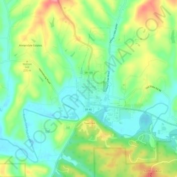
Name: Nashville topographic map, elevation, terrain.
Location: Nashville, Brown County, Indiana, United States (39.19162 -86.25095 39.22205 -86.19358)
Average elevation: 208 m
Minimum elevation: 172 m
Maximum elevation: 267 m
Other topographic maps
Click on a map to view its topography, its elevation and its terrain.
Helmsburg
United States > Indiana > Brown County
Helmsburg, Brown County, Indiana, 47435, United States
Average elevation: 222 m
Needmore
United States > Indiana > Brown County
Needmore, Brown County, Indiana, 47435, United States
Average elevation: 223 m
Becks Grove
United States > Indiana > Brown County
Becks Grove, Brown County, Indiana, United States
Average elevation: 239 m
Christiansburg
United States > Indiana > Brown County
Christiansburg, Brown County, Indiana, United States
Average elevation: 217 m
Fruitdale
United States > Indiana > Brown County
Fruitdale, Brown County, Indiana, 46160, United States
Average elevation: 247 m
Pikes Peak
United States > Indiana > Brown County
Pikes Peak, Brown County, Indiana, United States
Average elevation: 219 m
Camp Roberts
United States > Indiana > Brown County
Camp Roberts, Brown County, Indiana, United States
Average elevation: 226 m
Cornelius
United States > Indiana > Brown County
Cornelius, Brown County, Indiana, 47435, United States
Average elevation: 242 m
Clarksdale
United States > Indiana > Brown County
Clarksdale, Brown County, Indiana, United States
Average elevation: 242 m
Mount Liberty
United States > Indiana > Brown County
Mount Liberty, Brown County, Indiana, United States
Average elevation: 241 m
Lanam
United States > Indiana > Brown County
Lanam, Brown County, Indiana, 47435, United States
Average elevation: 242 m
Belmont
United States > Indiana > Brown County
Belmont, Brown County, Indiana, United States
Average elevation: 196 m
Elkinsville
United States > Indiana > Brown County
Elkinsville, Brown County, Indiana, United States
Average elevation: 200 m
Gatesville
United States > Indiana > Brown County
Gatesville, Brown County, Indiana, United States
Average elevation: 238 m
Peoga
United States > Indiana > Brown County
Peoga, Brown County, Indiana, 46164, United States
Average elevation: 280 m
Gnaw Bone
United States > Indiana > Brown County
Gnaw Bone, Brown County, Indiana, United States
Average elevation: 231 m
Stone Head
United States > Indiana > Brown County
Stone Head, Brown County, Indiana, United States
Average elevation: 214 m
Spearsville
United States > Indiana > Brown County
Spearsville, Brown County, Indiana, United States
Average elevation: 271 m
Kirkofer Lake Dam
United States > Indiana > Brown County
Kirkofer Lake Dam, Brown County, Indiana, United States
Average elevation: 241 m
Trevlac
United States > Indiana > Brown County
Trevlac, Brown County, Indiana, 47435, United States
Average elevation: 214 m
Taggart
United States > Indiana > Brown County
Taggart, Brown County, Indiana, United States
Average elevation: 237 m
Story
United States > Indiana > Brown County
Story, Brown County, Indiana, United States
Average elevation: 195 m
Beanblossom
United States > Indiana > Brown County
Beanblossom, Brown County, Indiana, 47435, United States
Average elevation: 233 m