
San Pedro topographic map
Interactive map
Click on the map to display elevation.
About this map
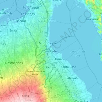
Name: San Pedro topographic map, elevation, terrain.
Location: San Pedro, Laguna, Calabarzon, 4023, Philippines (14.20367 120.89319 14.52367 121.21319)
Average elevation: 52 m
Minimum elevation: -2 m
Maximum elevation: 368 m
Other topographic maps
Click on a map to view its topography, its elevation and its terrain.
Langgam
Philippines > Laguna > San Pedro
Langgam, San Pedro, Laguna, Calabarzon, 4023, Philippines
Average elevation: 90 m