
Cramlington topographic map
Interactive map
Click on the map to display elevation.
About this map
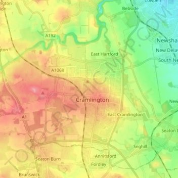
Name: Cramlington topographic map, elevation, terrain.
Average elevation: 51 m
Minimum elevation: 7 m
Maximum elevation: 98 m
Other topographic maps
Click on a map to view its topography, its elevation and its terrain.
Lanercost Nature Area
United Kingdom > England > Cramlington > East Cramlington
Lanercost Nature Area, High Pit, East Cramlington, Cramlington, Northumberland, North East England, England, United Kingdom
Average elevation: 52 m