
Florence topographic map
Interactive map
Click on the map to display elevation.
About this map
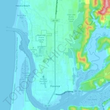
Name: Florence topographic map, elevation, terrain.
Location: Florence, Lane County, Oregon, United States (43.96413 -124.13343 44.03715 -124.07913)
Average elevation: 22 m
Minimum elevation: -6 m
Maximum elevation: 203 m
Other topographic maps
Click on a map to view its topography, its elevation and its terrain.
Fuji Mountain
United States > Oregon > Lane County
Fuji Mountain, Lane County, Oregon, United States
Average elevation: 1,885 m
Rainbow
United States > Oregon > Lane County > Rainbow
Rainbow, Lane County, Oregon, 97413, United States
Average elevation: 486 m
Oakridge
United States > Oregon > Lane County
Oakridge, Lane County, Oregon, 97463, United States
Average elevation: 465 m
Eugene
United States > Oregon > Lane County
Eugene, Lane County, Oregon, United States
Average elevation: 163 m
Springfield
United States > Oregon > Lane County > Springfield
Springfield, Lane County, Oregon, United States
Average elevation: 177 m
Creswell
United States > Oregon > Lane County
Creswell, Lane County, Oregon, 97426, United States
Average elevation: 165 m