
Arica topographic map
Interactive map
Click on the map to display elevation.
Arica
More than 20 km of beaches, many known for the quality of surfing, span across the Coastal Range in the northern sector. The harbored location makes these beaches unique from other cities in Chile in terms of topography.
About this map
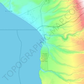
Name: Arica topographic map, elevation, terrain.
Average elevation: 523 m
Minimum elevation: 0 m
Maximum elevation: 3,622 m
Other topographic maps
Click on a map to view its topography, its elevation and its terrain.
Santuario de la Naturaleza y RENAMU Humedal Desembocadura Río Lluta
Chile > Arica and Parinacota Region > Provincia de Arica > Arica > Villa Frontera > Las Machas
Average elevation: 10 m