
Podgorica topographic map
Interactive map
Click on the map to display elevation.
About this map
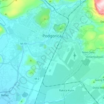
Name: Podgorica topographic map, elevation, terrain.
Location: Podgorica, Podgorica Capital City, Montenegro (42.37713 19.17973 42.47488 19.31406)
Average elevation: 75 m
Minimum elevation: 16 m
Maximum elevation: 574 m
In contrast to most of Montenegro, Podgorica lies in a mainly flat area at the northern end of the Zeta plain, at an elevation of 40 m (130 ft). The only exceptions are hills which overlook the city. The most significant is 130.3 m (427 ft) high Gorica Hill (pronounced [ˈɡǒrit͜sa]), city's namesake, which rises above the city centre. The other hills include Malo brdo ("little hill", 205.4 m or 674 ft), Velje brdo ("big hill", 283 m or 928 ft), Ljubović (101 m or 331 ft) and Dajbapska gora (172 m or 564 ft). Podgorica city proper has an area of 108 square kilometres (42 sq mi), while actual urbanized area is much smaller.
Other topographic maps
Click on a map to view its topography, its elevation and its terrain.
Carine
Montenegro > Podgorica Capital City
Carine, Podgorica Capital City, Montenegro
Average elevation: 1,722 m