
Lasswade topographic map
Interactive map
Click on the map to display elevation.
About this map
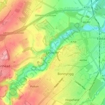
Name: Lasswade topographic map, elevation, terrain.
Location: Lasswade, Midlothian, Scotland, EH18 1ND, United Kingdom (55.86321 -3.13474 55.90321 -3.09474)
Average elevation: 97 m
Minimum elevation: 42 m
Maximum elevation: 158 m
Midlothian trails, hiking, mountain biking, running and outdoor activities
Other topographic maps
Click on a map to view its topography, its elevation and its terrain.
Straiton Pond Local Nature Reserve
United Kingdom > Scotland > Midlothian > Loanhead
Average elevation: 131 m