
Heanor topographic map
Interactive map
Click on the map to display elevation.
Heanor
Samuel Lewis's A Topographical Dictionary of England, published in 1848, states that Heanor parish "abounds with coal and ironstone, both worked extensively, the collieries alone affording employment to more than 2000 persons. The town is pleasantly situated upon an eminence, on the road from Derby to Mansfield. The principal articles of manufacture are silk and cotton goods, hosiery, and bobbinet lace, providing occupation to about 800 persons." The parish then covered 7,000 acres (2,800 ha) and was in the union of Basford and the hundred of Morleston and Litchurch, with Heanor town itself covering 1,500 acres (610 ha) with 3,058 inhabitants. The parish church, dedicated to St Mary, was "a very ancient edifice, with a lofty substantial tower, from which is an extensive view," though the dictionary noted there were also "places of worship for Baptists, Independents, Wesleyans, and Ranters".
About this map
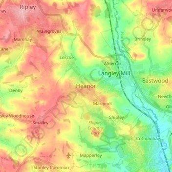
Name: Heanor topographic map, elevation, terrain.
Average elevation: 102 m
Minimum elevation: 45 m
Maximum elevation: 163 m
Derbyshire trails, hiking, mountain biking, running and outdoor activities
Other topographic maps
Click on a map to view its topography, its elevation and its terrain.
Nottingham Canal
United Kingdom > England > Derbyshire > Amber Valley > Langley Mill
Average elevation: 77 m
Shipley Country Park
United Kingdom > England > Derbyshire > Amber Valley > Marlpool
Average elevation: 93 m
Crich CP
United Kingdom > England > Derbyshire > Amber Valley
The memorial tower ('Crich Stand') was completed in 1923 as a memorial to the 11,409 soldiers from the Sherwood Foresters Regiment who died in World War I, a dedication that was later extended to include World War II. It was built on an limestone outcrop above the village, at an altitude of 1,000 feet (300 m)…
Average elevation: 159 m
Quarndon
United Kingdom > England > Derbyshire > Amber Valley
52°58′8″N 1°29′36″W / 52.96889°N 1.49333°W / 52.96889; -1.49333 This directional compass, provides details of bearings, distances, elevations and dates of nearly 50 places of special interest and was unveiled on 29 September 2001. It stands on an 8-ton block of Derbyshire gritstone – 140…
Average elevation: 96 m
Dethick, Lea and Holloway CP
United Kingdom > England > Derbyshire > Amber Valley > Dethick
Average elevation: 204 m