
Ashland topographic map
Interactive map
Click on the map to display elevation.
About this map
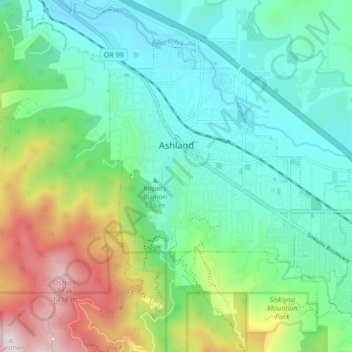
Name: Ashland topographic map, elevation, terrain.
Location: Ashland, Jackson County, Oregon, United States (42.16720 -122.73599 42.21605 -122.65110)
Average elevation: 774 m
Minimum elevation: 503 m
Maximum elevation: 1,477 m
Ashland lies within Oregon's southwest interior climate zone, in which all but the higher-elevation sites are in the rain shadow of the Oregon Coast Range to the west. The largest urban areas in this zone in addition to Ashland are Medford and Grants Pass in the Rogue Valley, and Roseburg in the Umpqua River Valley further north. Although the mountain peaks in this zone receive up to 120 inches or 3,050 millimetres of precipitation a year, the urban areas and the valleys in which they lie generally get 20 inches (510 mm) or less. This valley climate is particularly good for growing fruit, especially pears, and for producing other crops and farm goods such as hay, grain, poultry, and beef.
Other topographic maps
Click on a map to view its topography, its elevation and its terrain.
Medford
United States > Oregon > Jackson County
Medford, Jackson County, Oregon, United States
Average elevation: 441 m
Buncom
United States > Oregon > Jackson County
Buncom, Jackson County, Oregon, United States
Average elevation: 654 m
Lower Table Rock Trail
United States > Oregon > Jackson County
Lower Table Rock Trail, Jackson County, Oregon, United States
Average elevation: 453 m
Gold Hill
United States > Oregon > Jackson County
Gold Hill, Jackson County, Oregon, United States
Average elevation: 416 m
Rogue River
United States > Oregon > Jackson County
Rogue River, Jackson County, Oregon, 97537, United States
Average elevation: 362 m
Siskiyou Gap
United States > Oregon > Jackson County
Siskiyou Gap, Jackson County, Oregon, United States
Average elevation: 1,746 m
Jacksonville
United States > Oregon > Jackson County
Jacksonville, Jackson County, Oregon, 97530, United States
Average elevation: 522 m
Lakecreek
United States > Oregon > Jackson County
Lakecreek, Jackson County, Oregon, United States
Average elevation: 538 m