
Make a donation
Gear up for your next adventure:
As an Amazon Associate, this site earns from qualifying purchases at no extra cost to you.
Winston-Salem topographic map
Click on the map to display elevation.
Make a donation
Gear up for your next adventure:
As an Amazon Associate, this site earns from qualifying purchases at no extra cost to you.
About this map
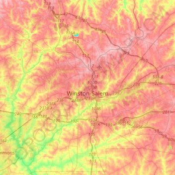
Name: Winston-Salem topographic map, elevation, terrain.
Location: Winston-Salem, Forsyth County, North Carolina, United States (35.99655 -80.38595 36.21816 -80.10097)
Average elevation: 263 m
Minimum elevation: 180 m
Maximum elevation: 313 m
Make a donation
Gear up for your next adventure:
As an Amazon Associate, this site earns from qualifying purchases at no extra cost to you.
Other topographic maps
Click on a map to view its topography, its elevation and its terrain.
Reynolda Village
United States > North Carolina > Forsyth County > Winston-Salem
Average elevation: 278 m
Make a donation
Gear up for your next adventure:
As an Amazon Associate, this site earns from qualifying purchases at no extra cost to you.
Reynolda Village
United States > North Carolina > Forsyth County > Winston-Salem
Average elevation: 278 m
Make a donation
Gear up for your next adventure:
As an Amazon Associate, this site earns from qualifying purchases at no extra cost to you.
Make a donation
Gear up for your next adventure:
As an Amazon Associate, this site earns from qualifying purchases at no extra cost to you.
Columbia Heights
United States > North Carolina > Forsyth County > Winston-Salem
Average elevation: 260 m
Make a donation
Gear up for your next adventure:
As an Amazon Associate, this site earns from qualifying purchases at no extra cost to you.
Briarcliff Manor
United States > North Carolina > Forsyth County > Winston-Salem
Average elevation: 248 m
Make a donation
Gear up for your next adventure:
As an Amazon Associate, this site earns from qualifying purchases at no extra cost to you.
West Highlands
United States > North Carolina > Forsyth County > Winston-Salem
Average elevation: 269 m