
Colonial Beach topographic map
Interactive map
Click on the map to display elevation.
About this map
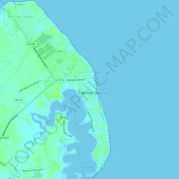
Name: Colonial Beach topographic map, elevation, terrain.
Location: Colonial Beach, Westmoreland County, Virginia, United States (38.22943 -77.00399 38.27469 -76.95692)
Average elevation: 2 m
Minimum elevation: -3 m
Maximum elevation: 13 m
Other topographic maps
Click on a map to view its topography, its elevation and its terrain.
Hinnom
United States > Virginia > Westmoreland County
Hinnom, Westmoreland County, Virginia, 22520, United States
Average elevation: 13 m
Latanes
United States > Virginia > Westmoreland County
Latanes, Westmoreland County, Virginia, 22443, United States
Average elevation: 15 m
Latanes Pond
United States > Virginia > Westmoreland County > Laurel Grove
Latanes Pond, Laurel Grove, Westmoreland County, Virginia, United States
Average elevation: 9 m
Leedstown
United States > Virginia > Westmoreland County
Leedstown, Westmoreland County, Virginia, United States
Average elevation: 6 m