
Mount Elbrus (East Summit) topographic map
Interactive map
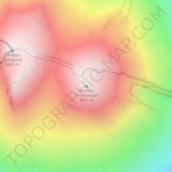
Click on the map to display elevation.
About this map
Name: Mount Elbrus (East Summit) topographic map, elevation, terrain.
Average elevation: 5,160 m
Minimum elevation: 4,429 m
Maximum elevation: 5,632 m
As Elbrus is located in the Northern Hemisphere, the summer period, the least rigorous, takes place from June to mid-September with an average of 50% of sunny days favorable to the ascent of the summit. However, the winds, dominated by westerly air masses, can turn violent and temperatures drop very quickly. Above 4000 meters above sea level, even in summer, arctic blizzard conditions with near zero visibility can develop. It is not uncommon for the wind to exceed 100 km/h. In winter, the temperature can drop below −50° at the top, but in the valleys hot, dry downdrafts can cause heavy snowfall. At low altitudes, the average precipitation is 500 mm and can reach 1000 mm in some years, while above 2000 meters it can exceed 1500 mm.
Other topographic maps
Click on a map to view its topography, its elevation and its terrain.
сельское поселение Лашкута
Russia > Kabardino-Balkaria > Elbrus District
сельское поселение Лашкута, Elbrus District, Kabardino-Balkaria, North Caucasian Federal District, Russia
Average elevation: 1,264 m
Tyrnyauz
Russia > Kabardino-Balkaria > Elbrus District
Tyrnyauz, городское поселение Тырныауз, Elbrus District, Kabardino-Balkaria, North Caucasian Federal District, 361624, Russia
Average elevation: 2,129 m