
Ķegums topographic map
Interactive map
Click on the map to display elevation.
About this map
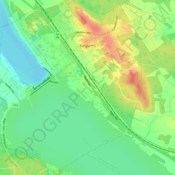
Name: Ķegums topographic map, elevation, terrain.
Location: Ķegums, Ogres novads, Zemgale, LV-5020, Latvia (56.72533 24.69187 56.75460 24.74383)
Average elevation: 38 m
Minimum elevation: 15 m
Maximum elevation: 69 m
Other topographic maps
Click on a map to view its topography, its elevation and its terrain.
Gāguļi
Latvia > Zemgale > Ogres novads > Birzgales pagasts
Gāguļi, Birzgales pagasts, Ogres novads, Zemgale, Latvia
Average elevation: 50 m
Suntaži
Latvia > Zemgale > Ogres novads > Suntažu pagasts
Suntaži, Suntažu pagasts, Ogres novads, Zemgale, LV-5060, Latvia
Average elevation: 70 m
Bekas
Latvia > Zemgale > Ogres novads > Lēdmanes pagasts > Bekas
Bekas, Lēdmanes pagasts, Ogres novads, Zemgale, LV-5011, Latvia
Average elevation: 76 m
Ogre
Latvia > Zemgale > Ogres novads > Ogre
Ogre, Ogres novads, Zemgale, Latvia
Average elevation: 29 m