
Glacier National Park topographic map
Interactive map
Click on the map to display elevation.
About this map
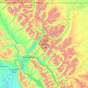
Name: Glacier National Park topographic map, elevation, terrain.
Location: Glacier National Park, Montana, 59916, United States (48.23370 -114.47550 49.00111 -113.24162)
Average elevation: 1,594 m
Minimum elevation: 888 m
Maximum elevation: 3,051 m
One of the most dramatic evidences of this overthrust is visible in the form of Chief Mountain, an isolated peak on the edge of the eastern boundary of the park rising 2,500 feet (800 m) above the Great Plains. There are six mountains in the park over 10,000 feet (3,000 m) in elevation, with Mount Cleveland at 10,466 feet (3,190 m) being the tallest. Appropriately named Triple Divide Peak sends waters towards the Pacific Ocean, Hudson Bay, and Gulf of Mexico watersheds. This peak can effectively be considered to be the apex of the North American continent, although the mountain is only 8,020 feet (2,444 m) above sea level.
Other topographic maps
Click on a map to view its topography, its elevation and its terrain.
Butte
United States > Montana > Silver Bow County
Butte, Silver Bow County, Montana, United States
Average elevation: 1,909 m
Logan
United States > Montana > Gallatin County
Logan, Gallatin County, Montana, United States
Average elevation: 1,294 m
Kalispell
United States > Montana > Flathead County
Kalispell, Flathead County, Montana, United States
Average elevation: 934 m
Trego
United States > Montana > Lincoln County
Trego, Lincoln County, Montana, 59934, United States
Average elevation: 974 m
Missoula
United States > Montana > Missoula County
Missoula, Missoula County, Montana, United States
Average elevation: 1,173 m
Stillwater County
Stillwater County, Montana, United States
Average elevation: 1,474 m
Carr Trailer Court
United States > Montana > Stillwater County > Columbus
Carr Trailer Court, Columbus, Stillwater County, Montana, United States
Average elevation: 1,119 m
Franklin Park
United States > Montana > Missoula County > Missoula
Franklin Park, Franklin to the Fort, Missoula, Missoula County, Montana, United States
Average elevation: 968 m
Red Rock River
United States > Montana > Beaverhead County > Dell
Red Rock River, Dell, Beaverhead County, Montana, United States
Average elevation: 1,834 m
Jackson
United States > Montana > Beaverhead County
Jackson, Beaverhead County, Montana, 59736, United States
Average elevation: 1,995 m
Lois Lake
United States > Montana > Powell County
Lois Lake, Powell County, Montana, United States
Average elevation: 1,671 m
Twin Bridges
United States > Montana > Madison County
Twin Bridges, Madison County, Montana, United States
Average elevation: 1,414 m
Flathead County
Flathead County, Montana, United States
Average elevation: 1,497 m
Lakeside
United States > Montana > Flathead County
Lakeside, Flathead County, Montana, 59922, United States
Average elevation: 1,034 m
Roosevelt County
Roosevelt County, Montana, United States
Average elevation: 703 m
Rattlesnake Wilderness
United States > Montana > Missoula County
Rattlesnake Wilderness, Missoula County, Montana, United States
Average elevation: 1,847 m
Wild Horse Island
United States > Montana > Lake County
Wild Horse Island, Lake County, Montana, United States
Average elevation: 916 m
Red Lodge
United States > Montana > Carbon County
Red Lodge, Carbon County, Montana, 59068, United States
Average elevation: 1,720 m
Victor
United States > Montana > Ravalli County
Victor, Ravalli County, Montana, United States
Average elevation: 1,047 m
Winston
United States > Montana > Broadwater County > Winston
Winston, Broadwater County, Montana, 59647, United States
Average elevation: 1,335 m
Jefferson County
Jefferson County, Montana, United States
Average elevation: 1,750 m
Treasure County
Treasure County, Montana, United States
Average elevation: 927 m
Petroleum County
Petroleum County, Montana, United States
Average elevation: 916 m
Thompson Park
United States > Montana > Silver Bow County > Butte
Thompson Park, Butte, Silver Bow County, Montana, United States
Average elevation: 1,870 m
Baldy
United States > Montana > Powell County
Baldy, Powell County, Montana, United States
Average elevation: 2,473 m
Riata Park
United States > Montana > Missoula County > Missoula
Riata Park, 44 Ranch, Orchard Homes, Missoula, Missoula County, Montana, United States
Average elevation: 961 m
Wisdom
United States > Montana > Beaverhead County > Wisdom
Wisdom, Beaverhead County, Montana, 59761, United States
Average elevation: 1,848 m
Ashenhurst Number 2 Dam
United States > Montana > Rosebud County
Ashenhurst Number 2 Dam, Rosebud County, Montana, United States
Average elevation: 955 m
Baker
United States > Montana > Fallon County
Baker, Fallon County, Montana, 59313, United States
Average elevation: 901 m
Sugar Loaf Mountain
United States > Montana > Park County
Sugar Loaf Mountain, Park County, Montana, United States
Average elevation: 2,343 m
McLeod
United States > Montana > Sweet Grass County
McLeod, Sweet Grass County, Montana, United States
Average elevation: 1,564 m
Hysham
United States > Montana > Treasure County
Hysham, Treasure County, Montana, United States
Average elevation: 810 m
St. Regis
United States > Montana > Mineral County
St. Regis, Mineral County, Montana, 59866, United States
Average elevation: 838 m
Seeley Lake
United States > Montana > Missoula County
Seeley Lake, Missoula County, Montana, United States
Average elevation: 1,348 m
Pray Lake
United States > Montana > Glacier County
Pray Lake, Glacier County, Montana, United States
Average elevation: 1,717 m
Baseline
United States > Montana > Yellowstone County
Baseline, Yellowstone County, Montana, 59103, United States
Average elevation: 1,043 m
Ski Hill
United States > Montana > Beaverhead County
Ski Hill, Beaverhead County, Montana, United States
Average elevation: 2,215 m
Bowman Lake
United States > Montana > Flathead County
Bowman Lake, Flathead County, Montana, United States
Average elevation: 1,639 m
Livingston
United States > Montana > Park County
Livingston, Park County, Montana, United States
Average elevation: 1,421 m
Poplar
United States > Montana > Roosevelt County
Poplar, Poplar District, Roosevelt County, Montana, United States
Average elevation: 600 m
Choteau
United States > Montana > Teton County
Choteau, Teton County, Montana, United States
Average elevation: 1,173 m
Plains
United States > Montana > Sanders County
Plains, Sanders County, Montana, United States
Average elevation: 775 m
Bozeman
United States > Montana > Gallatin County
Bozeman, Gallatin County, Montana, United States
Average elevation: 1,495 m
Wolf Creek
United States > Montana > Lincoln County
Wolf Creek, Lincoln County, Montana, United States
Average elevation: 1,225 m
Gluten
United States > Montana > Daniels County
Gluten, Daniels County, Montana, United States
Average elevation: 816 m
Ozone Layer Dam
United States > Montana > Wheatland County
Ozone Layer Dam, Wheatland County, Montana, United States
Average elevation: 1,413 m
Emigrant
United States > Montana > Park County
Emigrant, Park County, Montana, 59027, United States
Average elevation: 1,530 m
Martin City
United States > Montana > Flathead County > Martin City
Martin City, Flathead County, Montana, 59926, United States
Average elevation: 989 m
Ear Mountain
United States > Montana > Teton County
Ear Mountain, Teton County, Montana, United States
Average elevation: 2,138 m