
Make a donation
Gear up for your next adventure:
As an Amazon Associate, this site earns from qualifying purchases at no extra cost to you.
Salton Sea topographic map
Click on the map to display elevation.
Make a donation
Gear up for your next adventure:
As an Amazon Associate, this site earns from qualifying purchases at no extra cost to you.
Salton Sea
The lake occupies the lowest elevations of the Salton Sink in the Colorado Desert of Imperial and Riverside counties in Southern California. Its surface is 236.0 ft (71.9 m) below sea level as of January 2018. The deepest point of the sea is 5 ft (1.5 m) higher than the lowest point of Death Valley. The sea is fed by the New, Whitewater, and Alamo rivers, as well as agricultural runoff, drainage systems, and creeks.
Make a donation
Gear up for your next adventure:
As an Amazon Associate, this site earns from qualifying purchases at no extra cost to you.
About this map
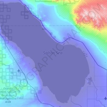
Name: Salton Sea topographic map, elevation, terrain.
Location: Salton Sea, California, United States of America (33.09268 -116.08306 33.53159 -115.58713)
Average elevation: 17 m
Minimum elevation: -73 m
Maximum elevation: 897 m
Make a donation
Gear up for your next adventure:
As an Amazon Associate, this site earns from qualifying purchases at no extra cost to you.
Other topographic maps
Click on a map to view its topography, its elevation and its terrain.
Riverside
United States of America > California > Riverside
Riverside is the 59th largest city in the United States, the 12th largest city in California, and the largest city in California's Inland Empire metro area. According to the United States Census Bureau, the city has a total area of 81.4 square miles (210.8 km2), of which 81.1 square miles (210 km2) is land and…
Average elevation: 351 m
Lake Elsinore
United States of America > California > Lake Elsinore
The rainfall until 1893 was greater than normal, and the lake remained high and overflowed naturally on three or four occasions during that time. The lake water was purchased by the Temescal Water Company for the irrigation of land in Corona. Its outlet channel was deepened, permitting gravity flow down the…
Average elevation: 531 m
Beaumont
United States of America > California > Beaumont
Beaumont is a city in Riverside County, California, United States, located at a half-mile elevation in the pass area south of Southern California's highest peak, San Gorgonio Mountain, and north of San Jacinto Peak.
Average elevation: 725 m
Make a donation
Gear up for your next adventure:
As an Amazon Associate, this site earns from qualifying purchases at no extra cost to you.
Palmdale
United States of America > California > Palmdale
Downtown Palmdale is located at 34°34′46″N 118°07′00″W / 34.57944°N 118.11667°W / 34.57944; -118.11667, at an elevation of 2,655 feet (809 m) above sea level.
Average elevation: 898 m
Make a donation
Gear up for your next adventure:
As an Amazon Associate, this site earns from qualifying purchases at no extra cost to you.