
Tehran Province topographic map
Interactive map
Click on the map to display elevation.
About this map
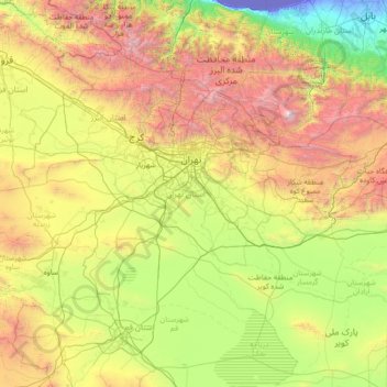
Name: Tehran Province topographic map, elevation, terrain.
Location: Tehran Province, Iran (34.86524 50.33279 36.10161 53.15690)
Average elevation: 1,435 m
Minimum elevation: -29 m
Maximum elevation: 5,455 m
Other topographic maps
Click on a map to view its topography, its elevation and its terrain.
Marran-e `Olya
Iran > Kurdistan Province > Divandarreh County > دهستان اوباتو
Average elevation: 2,161 m
Gold
Iran > Chaharmahal and Bakhtiyari Province > Lordegan County > Sardasht Rural District
Average elevation: 1,739 m
سرترتاب حاجی آباد
Iran > Khuzestan Province > Ramhormoz County > دهستان ابوالفارس
Average elevation: 700 m
Qorveh
Iran > Kurdistan Province > Ghorveh County > Ghorveh City
Qorveh is home to numerous peaks and elevations. Among them, the most noteworthy are Mount Parishaan, Mount Badr, Panjeh Ali, Ebrahim Attar, Yousef Siah, Shaban Kechal, Khersa Rih, and Seh Zardeh. The most significant of these are Mount Badr and Mount Parishaan.
Average elevation: 1,923 m
Inferior Bonivar
Iran > Khuzestan Province > Bandar-e-Mahshahr County > دهستان جراحی
Average elevation: 14 m
غضنفرخانی
Iran > Kohgiluye and Buyer Ahmad Province > Buyerahmad County > دهستان کاکان
Average elevation: 2,434 m
Alhashem-e Olya
Iran > Ardabil Province > Kahlkhal County > دهستان خانندبیل شرقی
Average elevation: 2,131 m
Zagros Mountains
Iran > Isfahan Province > Semirom County > Padena-ye Vosta RD
Average elevation: 3,846 m
Asemanabad- Ghalaje Paraglider Takeoff Site
Iran > Ilam Province > Chardavol County > Kol Kol Rural District
Average elevation: 1,747 m
سعیدآباد
Iran > West Azerbaijan Province > Shahin Dezh County > دهستان کشاورز
Average elevation: 1,355 m
Gold
Iran > Chaharmahal and Bakhtiyari Province > Lordegan County > Sardasht Rural District
Average elevation: 1,739 m