
Asunción Nochixtlán topographic map
Interactive map
Click on the map to display elevation.
About this map
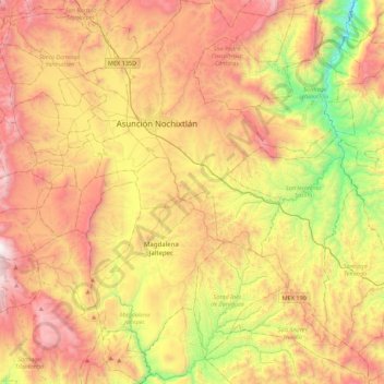
Name: Asunción Nochixtlán topographic map, elevation, terrain.
Location: Asunción Nochixtlán, Oaxaca, Mexico (17.17339 -97.28740 17.59158 -96.99875)
Average elevation: 2,126 m
Minimum elevation: 1,239 m
Maximum elevation: 3,041 m
Other topographic maps
Click on a map to view its topography, its elevation and its terrain.
Oaxaca City
Mexico > Oaxaca > Oaxaca de Juárez
Oaxaca has a tropical savanna climate (Köppen climate classification Aw), closely bordering on a humid subtropical climate (Cwa), due to its high altitude. During the dry season, temperatures during the day remain warm with an average high of 27.1 °C (80.8 °F) in the coolest month, December, and an average…
Average elevation: 1,838 m
Tamazulápam
Mexico > Oaxaca > Villa de Tamazulápam del Progreso > Tamazulápam
Average elevation: 2,063 m