
Acadia National Park topographic map
Interactive map
Click on the map to display elevation.
About this map
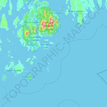
Name: Acadia National Park topographic map, elevation, terrain.
Average elevation: 9 m
Minimum elevation: -3 m
Maximum elevation: 452 m
The ecological zones at Acadia National Park, from highest to lowest elevation, include: nearly barren mountain summits; northern boreal and eastern deciduous forests on the mountainsides; freshwater lakes and ponds, as well as wetlands like marshes and swamps in the valleys between mountains; and the Atlantic shoreline with rocky and sandy beaches, intertidal and subtidal zones.
Other topographic maps
Click on a map to view its topography, its elevation and its terrain.
Otter Cliffs
United States > Maine > Hancock County > Bar Harbor
Otter Cliffs, Bar Harbor, Hancock County, Maine, United States
Average elevation: 13 m