
Sunyani topographic map
Click on the map to display elevation.
Gear up for your next adventure:
As an Amazon Associate, this site earns from qualifying purchases at no extra cost to you.
Sunyani
Sunyani is located at 07°20′N 02°20′W / 7.333°N 2.333°W / 7.333; -2.333 (7.333333, -2.333333), approximately 105 miles (169 km) southwest of Kumasi and 300 miles (480 km) away from Accra. The city have an average elevation of 308 metres (1,010 ft).
About this map
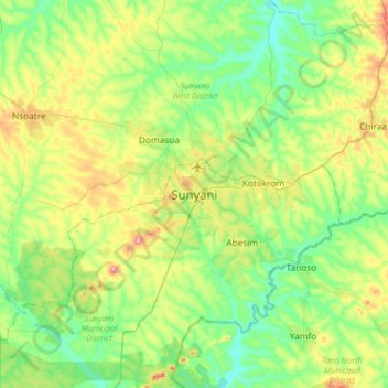
Name: Sunyani topographic map, elevation, terrain.
Location: Sunyani, Sunyani Municipal District, Bono Region, Ghana (7.17844 -2.49092 7.49844 -2.17092)
Average elevation: 276 m
Minimum elevation: 207 m
Maximum elevation: 426 m