
Damavand topographic map
Interactive map
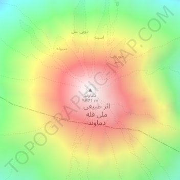
Click on the map to display elevation.
About this map
Name: Damavand topographic map, elevation, terrain.
Average elevation: 4,946 m
Minimum elevation: 4,310 m
Maximum elevation: 5,595 m
Mount Damavand (Persian: دماوند [dæmɒːvænd] (listen)) is a potentially active stratovolcano, the highest peak in Iran and Western Asia and the highest volcano in Asia and the 2nd highest volcano in the Eastern Hemisphere (after Mount Kilimanjaro), at an elevation of 5,671 metres (18,606 ft). Damāvand has a special place in Persian mythology and folklore. It is in the middle of the Alborz range, adjacent to Varārū, Sesang, Gol-e Zard, and Mīānrūd. It is near the southern coast of the Caspian Sea, in Amol County, Mazandaran Province, 66 km (41 mi) northeast of the city of Tehran.
Other topographic maps
Click on a map to view its topography, its elevation and its terrain.
Namar
Iran > Mazandaran Province > Amol County > دهستان لاریجان سفلی > Namar
Namar, دهستان لاریجان سفلی, بخش لاریجان, Amol County, Mazandaran Province, Iran
Average elevation: 2,452 m
دهستان لاریجان سفلی
Iran > Mazandaran Province > Amol County > دهستان لاریجان سفلی
دهستان لاریجان سفلی, بخش لاریجان, Amol County, Mazandaran Province, Iran
Average elevation: 2,569 m