
Shropshire (Ceremonial) topographic map
Interactive map
Click on the map to display elevation.
About this map
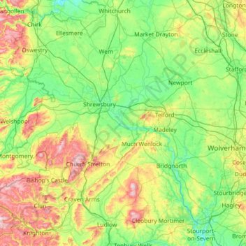
Name: Shropshire (Ceremonial) topographic map, elevation, terrain.
Location: Shropshire (Ceremonial), England, United Kingdom (52.30626 -3.23554 52.99839 -2.23290)
Average elevation: 143 m
Minimum elevation: 16 m
Maximum elevation: 541 m
The climate of Shropshire is moderate. Rainfall averages 760 to 1,000 mm (30 to 40 in), influenced by being in the rainshadow of the Cambrian Mountains from warm, moist frontal systems of the Atlantic Ocean which bring generally light precipitation in Autumn and Spring. The hilly areas in the south and west are much colder in the winter, due to their high elevation, they share a similar climate to that of the Welsh Marches and Mid-Wales. The flat northern plain in the north and east has a similar climate to that of the rest of the West Midlands.
Other topographic maps
Click on a map to view its topography, its elevation and its terrain.
London
United Kingdom > England > London
London, Greater London, England, SW1A 2DX, United Kingdom
Average elevation: 42 m
Birmingham
Birmingham, West Midlands Combined Authority, England, United Kingdom
Average elevation: 138 m
Sheffield
Sheffield, South Yorkshire, England, United Kingdom
Average elevation: 168 m
London
London, Greater London, England, United Kingdom
Average elevation: 66 m
North Norfolk
United Kingdom > England > Norfolk
North Norfolk, Norfolk, England, United Kingdom
Average elevation: 26 m
Hampshire
Hampshire, South East, England, United Kingdom
Average elevation: 73 m
Plymouth
United Kingdom > England > Devon > Plymouth
Plymouth, Devon, South West England, England, PL1 1HH, United Kingdom
Average elevation: 81 m
Bristol
United Kingdom > England > City of Bristol
Bristol, City of Bristol, West of England, England, United Kingdom
Average elevation: 55 m
Liverpool
Liverpool, Liverpool City Region, England, United Kingdom
Average elevation: 26 m
Leicester
United Kingdom > England > Leicestershire
Leicester, Leicestershire, England, LE1 5YA, United Kingdom
Average elevation: 109 m
Lake District National Park
Lake District National Park, England, United Kingdom
Average elevation: 206 m
Cambridgeshire
Cambridgeshire, Cambridgeshire and Peterborough, England, United Kingdom
Average elevation: 32 m
Cheltenham
United Kingdom > England > Gloucestershire
Cheltenham, Gloucestershire, England, United Kingdom
Average elevation: 109 m
Bath
United Kingdom > England > Bath and North East Somerset
Bath, Bath and North East Somerset, West of England, England, United Kingdom
Average elevation: 100 m
South East England
South East England, England, United Kingdom
Average elevation: 69 m
Weeley Heath
United Kingdom > England > Essex
Weeley Heath, Tendring, Essex, England, CO16 9BG, United Kingdom
Average elevation: 21 m
Greater Manchester
Greater Manchester, England, United Kingdom
Average elevation: 141 m
Northumberland
Northumberland, North of Tyne, England, United Kingdom
Average elevation: 141 m
Manchester
Manchester, Greater Manchester, England, United Kingdom
Average elevation: 66 m
Oxford
United Kingdom > England > Oxfordshire
Oxford, Oxfordshire, England, United Kingdom
Average elevation: 81 m
Chesterfield
United Kingdom > England > Derbyshire
Chesterfield, Derbyshire, England, United Kingdom
Average elevation: 127 m
Norwich
United Kingdom > England > Norfolk
Norwich, Norfolk, England, United Kingdom
Average elevation: 28 m
Swindon
United Kingdom > England > Swindon
Swindon, England, SN1 1LF, United Kingdom
Average elevation: 108 m
Nottingham
United Kingdom > England > Nottinghamshire
Nottingham, England, United Kingdom
Average elevation: 56 m
Newby Wiske
United Kingdom > England > North Yorkshire
Newby Wiske, North Yorkshire, England, United Kingdom
Average elevation: 31 m
Enborne Row
United Kingdom > England > West Berkshire
Enborne Row, West Berkshire, England, RG20 0PR, United Kingdom
Average elevation: 112 m
South Pool
United Kingdom > England > Devon > South Hams
South Pool, South Hams, Devon, England, United Kingdom
Average elevation: 38 m
Stibb Cross
United Kingdom > England > Devon > Torridge District
Stibb Cross, Langtree, Torridge District, Devon, England, EX38 8HZ, United Kingdom
Average elevation: 157 m
Brent Eleigh
United Kingdom > England > Suffolk > Babergh
Brent Eleigh, Babergh, Suffolk, England, United Kingdom
Average elevation: 64 m
Westridge Green
United Kingdom > England > West Berkshire > Aldworth
Westridge Green, Aldworth, West Berkshire, England, RG8 9RF, United Kingdom
Average elevation: 145 m
Leeds
United Kingdom > England > Leeds
Leeds, Yorkshire and the Humber, England, LS1 6AL, United Kingdom
Average elevation: 94 m
Castleton
United Kingdom > England > Derbyshire > High Peak
Castleton, High Peak, Derbyshire, England, United Kingdom
Average elevation: 326 m
Buxton
United Kingdom > England > Derbyshire > High Peak
Buxton, High Peak, Derbyshire, England, United Kingdom
Average elevation: 334 m
East of England
East of England, England, United Kingdom
Average elevation: 39 m
Shropshire
Shropshire, West Midlands, England, United Kingdom
Average elevation: 166 m
North West England
North West England, England, United Kingdom
Average elevation: 118 m
Chiltern District
United Kingdom > England > Buckinghamshire > Chalfont St Peter
Chiltern District, Chalfont St Peter, Buckinghamshire, England, United Kingdom
Average elevation: 137 m
North East England
North East England, England, United Kingdom
Average elevation: 165 m