
Brussels-Capital topographic map
Interactive map
Click on the map to display elevation.
About this map
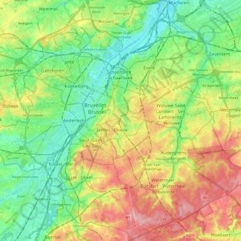
Name: Brussels-Capital topographic map, elevation, terrain.
Location: Brussels-Capital, Belgium (50.76368 4.24377 50.91390 4.48227)
Average elevation: 62 m
Minimum elevation: 10 m
Maximum elevation: 140 m
Brussels lies in the north-central part of Belgium, about 110 km (68 mi) from the Belgian coast and about 180 km (110 mi) from Belgium's southern tip. It is located in the heartland of the Brabantian Plateau, about 45 km (28 mi) south of Antwerp (Flanders), and 50 km (31 mi) north of Charleroi (Wallonia). Its average elevation is 57 m (187 ft) above sea level, varying from a low point in the valley of the almost completely covered Senne, which cuts the Brussels-Capital Region from east to west, up to high points in the Sonian Forest, on its southeastern side. In addition to the Senne, tributary streams such as the Maalbeek and the Woluwe, to the east of the region, account for significant elevation differences. Brussels' central boulevards are 15 m (49 ft) above sea level.[79] Contrary to popular belief, the highest point (at 127.5 m (418 ft)) is not near the Place de l'Altitude Cent/Hoogte Honderdplein in Forest, but at the Drève des Deux Montages/Tweebergendreef in the Sonian Forest.[80]
Other topographic maps
Click on a map to view its topography, its elevation and its terrain.
Leuven
Belgium > Flemish Brabant > Leuven
Leuven, Flemish Brabant, Flanders, Belgium
Average elevation: 43 m
Ghent
Belgium > East Flanders > Gent
Ghent, Gent, East Flanders, Flanders, Belgium
Average elevation: 7 m
Imde
Belgium > Flemish Brabant > Halle-Vilvoorde > Wolvertem
Imde, Wolvertem, Meise, Halle-Vilvoorde, Flemish Brabant, Flanders, 1861, Belgium
Average elevation: 20 m
Rijkevorsel
Rijkevorsel, Turnhout, Antwerp, Flanders, 2310, Belgium
Average elevation: 24 m
Heurne
Belgium > East Flanders > Oudenaarde > Oudenaarde
Heurne, Oudenaarde, East Flanders, Flanders, Belgium
Average elevation: 17 m
Battle of Waterloo
Belgium > Walloon Brabant > Waterloo
Battle of Waterloo, Route du Lion, Waterloo, Nivelles, Walloon Brabant, Wallonia, 1410, Belgium
Average elevation: 121 m
Houthulst
Belgium > West Flanders > Diksmuide
Houthulst, Diksmuide, West Flanders, Flanders, 8650, Belgium
Average elevation: 18 m
Torhout
Belgium > West Flanders > Brugge
Torhout, Brugge, West Flanders, Flanders, 8820, Belgium
Average elevation: 22 m
Wemmel
Belgium > Flemish Brabant > Halle-Vilvoorde
Wemmel, Halle-Vilvoorde, Flemish Brabant, 1780, Belgium
Average elevation: 51 m
Boonwijk
Belgium > East Flanders > Dendermonde > Dendermonde > Sint-Gillis-bij-Dendermonde
Boonwijk, Sint-Gillis-bij-Dendermonde, Dendermonde, East Flanders, 9200, Belgium
Average elevation: 4 m
Den Dotter
Belgium > East Flanders > Aalst > Haaltert
Den Dotter, Gotegemstraat, Haaltert, Aalst, East Flanders, 9450, Belgium
Average elevation: 45 m
Schönberg
Belgium > Liège > Verviers > Saint Vith
Schönberg, Saint Vith, Verviers, Liège, Wallonia, 4780, Belgium
Average elevation: 493 m
Conrad
Belgium > Namur > Dinant > Vresse-sur-Semois
Conrad, Vresse-sur-Semois, Dinant, Namur, Wallonia, 5550, Belgium
Average elevation: 314 m
Heuvelland
Belgium > West Flanders > Ieper
Heuvelland, Ieper, West Flanders, Belgium
Average elevation: 35 m
Forchies-la-Marche
Belgium > Hainaut > Charleroi > Fontaine-l'Évêque
Forchies-la-Marche, Fontaine-l'Évêque, Charleroi, Hainaut, Wallonia, 6141, Belgium
Average elevation: 171 m
Sint-Lievens-Esse
Belgium > East Flanders > Aalst
Sint-Lievens-Esse, Herzele, Aalst, East Flanders, Flanders, Belgium
Average elevation: 61 m
Sombeke
Belgium > East Flanders > Dendermonde > Waasmunster
Sombeke, Waasmunster, Dendermonde, East Flanders, Flanders, 9250, Belgium
Average elevation: 15 m
Kaster
Belgium > West Flanders > Kortrijk > Anzegem
Kaster, Anzegem, Kortrijk, West Flanders, 8572, Belgium
Average elevation: 25 m
Meer
Belgium > Antwerp > Turnhout > Hoogstraten
Meer, Hoogstraten, Turnhout, Antwerp, Flanders, 2321, Belgium
Average elevation: 11 m
Anzegem
Belgium > West Flanders > Kortrijk
Anzegem, Kortrijk, West Flanders, Belgium
Average elevation: 32 m
Eeklo
Belgium > East Flanders > Eeklo > Eeklo
Eeklo, East Flanders, Flanders, 9900, Belgium
Average elevation: 5 m
Hollogne-sur-Geer
Hollogne-sur-Geer, Geer, Waremme, Liège, Wallonia, 4250, Belgium
Average elevation: 129 m
Sint-Pieters-Leeuw
Belgium > Flemish Brabant > Halle-Vilvoorde > Sint-Pieters-Leeuw
Sint-Pieters-Leeuw, Halle-Vilvoorde, Flemish Brabant, 1600, Belgium
Average elevation: 42 m
Winterslag
Winterslag, Genk, Hasselt, Limburg, 3600, Belgium
Average elevation: 71 m
Drongen
Belgium > East Flanders > Gent > Ghent
Drongen, Ghent, Gent, East Flanders, 9031, Belgium
Average elevation: 7 m
Marbehan
Belgium > Luxembourg > Virton
Marbehan, Rulles, Habay, Virton, Luxembourg, Wallonia, 6724, Belgium
Average elevation: 370 m
Vresse-sur-Semois
Vresse-sur-Semois, Dinant, Namur, Wallonia, 5550, Belgium
Average elevation: 328 m
Borgerhout
Belgium > Antwerp > Antwerp > Antwerp
Borgerhout, Antwerp, Flanders, 2140, Belgium
Average elevation: 8 m
Sint-Truiden
Sint-Truiden, Hasselt, Limburg, Flanders, Belgium
Average elevation: 58 m
Ortheuville
Belgium > Luxembourg > Marche-en-Famenne
Ortheuville, Tenneville, Marche-en-Famenne, Luxembourg, Wallonia, 6970, Belgium
Average elevation: 395 m
Tillet
Belgium > Luxembourg > Bastogne
Tillet, Sainte-Ode, Bastogne, Luxembourg, Wallonia, 6680, Belgium
Average elevation: 465 m
Grand-Marchin
Belgium > Liège > Huy > Marchin
Grand-Marchin, Marchin, Huy, Liège, Wallonia, 4570, Belgium
Average elevation: 225 m