
River Chor topographic map
Interactive map
Click on the map to display elevation.
About this map
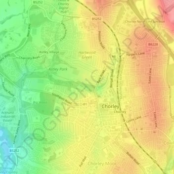
Name: River Chor topographic map, elevation, terrain.
Average elevation: 83 m
Minimum elevation: 34 m
Maximum elevation: 125 m
Other topographic maps
Click on a map to view its topography, its elevation and its terrain.
Clayton-le-Woods
United Kingdom > England > Chorley > Clayton-le-Woods
Clayton-le-Woods, Chorley, Lancashire, North West England, England, PR25 5RY, United Kingdom
Average elevation: 59 m
Eccleston
United Kingdom > England > Chorley
Eccleston, Chorley, Lancashire, North West England, England, United Kingdom
Average elevation: 29 m
Anglezarke
United Kingdom > England > Chorley
Anglezarke, Chorley, Lancashire, North West England, England, United Kingdom
Average elevation: 255 m
Cuerden
United Kingdom > England > Chorley > Cuerden
Cuerden, Chorley, Lancashire, North West England, England, United Kingdom
Average elevation: 59 m
River Yarrow
United Kingdom > England > Chorley
River Yarrow, Chorley, Lancashire, North West England, England, BL6 7SJ, United Kingdom
Average elevation: 282 m