
Mason City topographic map
Interactive map
Click on the map to display elevation.
About this map
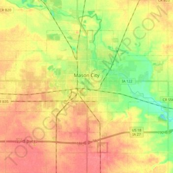
Name: Mason City topographic map, elevation, terrain.
Location: Mason City, Cerro Gordo County, Iowa, United States (43.10464 -93.28039 43.18411 -93.11245)
Average elevation: 352 m
Minimum elevation: 317 m
Maximum elevation: 378 m
Other topographic maps
Click on a map to view its topography, its elevation and its terrain.
Rockwell
United States > Iowa > Cerro Gordo County
Rockwell, Cerro Gordo County, Iowa, United States
Average elevation: 343 m
Clear Lake
United States > Iowa > Cerro Gordo County
Clear Lake, Cerro Gordo County, Iowa, 50428, United States
Average elevation: 373 m
Clear Lake
United States > Iowa > Cerro Gordo County > Clear Lake > Clear Lake
Clear Lake, Cerro Gordo County, Iowa, 50428, United States
Average elevation: 373 m