
Sestri Levante topographic map
Interactive map
Click on the map to display elevation.
About this map
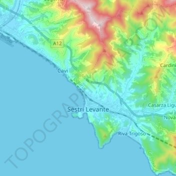
Name: Sestri Levante topographic map, elevation, terrain.
Location: Sestri Levante, Genoa, Liguria, 16039, Italy (44.23804 9.38429 44.32629 9.47156)
Average elevation: 114 m
Minimum elevation: -3 m
Maximum elevation: 686 m
Other topographic maps
Click on a map to view its topography, its elevation and its terrain.
Santo Stefano d'Aveto
Santo Stefano d'Aveto, Genoa, Liguria, Italy
Average elevation: 1,166 m
Villetta Di Negro
Italy > Liguria > Genoa > Genoa
Villetta Di Negro, Genoa, Liguria, 16122, Italy
Average elevation: 53 m