
Sagarmatha topographic map
Interactive map
Click on the map to display elevation.
About this map
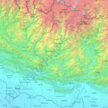
Name: Sagarmatha topographic map, elevation, terrain.
Location: Sagarmatha, Province #1, Nepal (26.42244 86.13113 28.11375 87.16823)
Average elevation: 1,771 m
Minimum elevation: 52 m
Maximum elevation: 8,836 m
Other topographic maps
Click on a map to view its topography, its elevation and its terrain.
Mount Everest
Nepal > Eastern Development Region > Qutang > Khumjung
Mount Everest, Khumjung, Solukhumbu, Sagarmatha, Eastern Development Region, Nepal
Average elevation: 7,841 m
Dhankuta
Nepal > Eastern Development Region > Dhankuta
Dhankuta, Koshi, Eastern Development Region, Nepal
Average elevation: 1,066 m
Thame
Nepal > Eastern Development Region > Thame
Thame, Solukhumbu, Sagarmatha, Eastern Development Region, Nepal
Average elevation: 4,122 m
Nuptse I
Nepal > Eastern Development Region > Khumjung
Nuptse I, Khumjung, Solukhumbu, Sagarmatha, Eastern Development Region, Nepal
Average elevation: 6,836 m
Narayanganj
Nepal > Eastern Development Region > Narayanganj
Narayanganj, Mechinagar, Jhapa, Mechi, Eastern Development Region, Nepal
Average elevation: 282 m
Daulatpur
Nepal > Eastern Development Region > Daulatpur
Daulatpur, Saptari, Sagarmatha, Eastern Development Region, Nepal
Average elevation: 122 m
Lhotse Shar
Nepal > Eastern Development Region > Khumjung
Lhotse Shar, Khumjung, Solukhumbu, Sagarmatha, Eastern Development Region, Nepal
Average elevation: 7,153 m
Ngozumpa Glacier
Nepal > Eastern Development Region > Khumjung > Khumjung
Ngozumpa Glacier, Khumjung, Solukhumbu, Sagarmatha, Eastern Development Region, Nepal
Average elevation: 5,632 m
Dharampur
Nepal > Eastern Development Region > Dharampur
Dharampur, Jhapa, Mechi, Eastern Development Region, Nepal
Average elevation: 114 m
Eastern Development Region
Nepal > Eastern Development Region
Eastern Development Region, Nepal
Average elevation: 2,220 m