
Manhattan topographic map
Interactive map
Click on the map to display elevation.
About this map
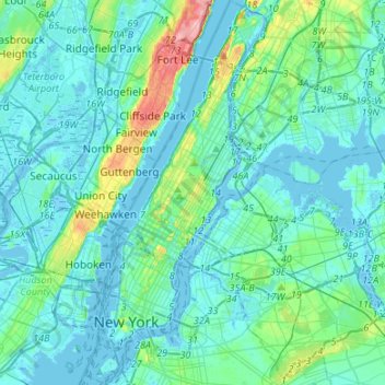
Name: Manhattan topographic map, elevation, terrain.
Location: Manhattan, New York County, New York, United States (40.67965 -74.04721 40.88201 -73.90677)
Average elevation: 16 m
Minimum elevation: -9 m
Maximum elevation: 117 m
Marble Hill is one example of how Manhattan's land has been considerably altered by human intervention. The borough has seen substantial land reclamation along its waterfronts since Dutch colonial times, and much of the natural variation in its topography has been evened out.
Other topographic maps
Click on a map to view its topography, its elevation and its terrain.
Central Park
United States > New York > New York County > New York
Central Park, New York County, New York, United States
Average elevation: 26 m
Governors Island
United States > New York > New York County > New York
Governors Island, Manhattan, New York County, New York, United States
Average elevation: 1 m
Battery Park
United States > New York > New York County > New York
Battery Park, Financial District, Manhattan, New York County, New York, 10004, United States
Average elevation: 3 m
Highbridge Park
United States > New York > New York County > New York
Highbridge Park, Manhattan, New York County, New York, United States
Average elevation: 30 m
Manhattan Community Board 3
United States > New York > New York County > New York
Manhattan Community Board 3, Manhattan, New York County, New York, United States, Seward Park
Average elevation: 10 m
Hunter’s Point South Waterfront Park
United States > New York > New York County > New York
Hunter’s Point South Waterfront Park, Manhattan Community Board 6, Manhattan, New York County, New York, United States
Average elevation: 5 m
Roosevelt Island
United States > New York > New York County > New York
Roosevelt Island, Manhattan, New York County, New York, 10044, United States
Average elevation: 13 m